Cei Mawr
| Cei Mawr | |||||||||
|---|---|---|---|---|---|---|---|---|---|
 Bleasdale Photograph | |||||||||
| Status | Location | ||||||||
| Location | |||||||||
| Latitude | 52:56:43.67N | ||||||||
| Longitude | 04:02:24.93W | ||||||||
| Grid reference | SH638404 | ||||||||
| Route Navigator | |||||||||
| |||||||||
| Stations | Locations | Bridges | Tunnels | Map | |||||||||
Cei Mawr (English: Big Quay or Wall, a name applied from the earliest documentation), which is just after Rhiw Goch on the up journey, is one of the most impressive structures along the line. It is a tall, curved, dry-stone embankment that stands some 62 feet above the level of the stream below. It is said to be the largest drystone structure in Europe. Since construction, numerous repairs have been required and the present structure is significantly wider than the original as a result of the addition of strengthening buttresses along its whole length.
Amongst the first was between 1887 and 1890 when nearly £1000 was spent on strengthening work including the building of buttresses on both the north-east side and the south-eastern end. In earlier days sidings existed at both ends, to the north for Bwlch-y-Plwm lead mine and at the south for Catherine and Jane Lead Mining Company Ltd.
The latter ran off FR property for a short distance through the gate at Leadmine Curve. It was removed when the mine closed in 1876 but replaced for the handling of materials during the 1880s refurbishment of the embankment.[1]
More recently work was undertaken in 1989 and major repairs to the culvert at the base were completed in 1992.[video 1]
In early 2008, with the aid of outside agencies, a major felling operation took place which has restored the views around the Cei Mawr area that had been obliterated by conifer growth. This was a great improvement. The FR aided the removal of felled trees from the area. These were later shipped to Minffordd yard, seen here en route on the mineral line. This particular load, being of fairly large diameter, was destined to be milled by the owners - the National Trust.
-

Loading up near Cei Mawr, 2008
-

Returning to Minffordd Yard, 2008


Gallery[edit]
-

The area around 1887. Most of the open land in the photograph became covered by a conifer plantation which was felled in 2008
-

Buttress, probably the one added in 1890, in 2007
-

Culvert beneath Cei Mawr, 2007
-

Looking across the top towards Porthmadog, 2007
-
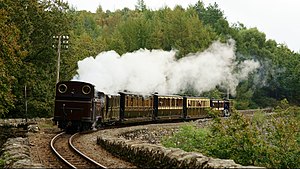
Taliesin with a vintage train during Steam 150 in 2013.
-

Palmerston with a vintage goods train during Steam 150 in 2013.


.jpg)
.jpg)
See also[edit]
References[edit]
- ^ Boyd, James I.C. (1975) [1959]. The Festiniog Railway 1800 - 1974; Vol. 2 Locomotive and Rolling Stock and Quarry Feeders. Blandford: The Oakwood Press. ISBN 085361-168-8.