Porthmadog (WHHR)
Overview
[edit]| Porthmadog (WHHR) | |||||||||
|---|---|---|---|---|---|---|---|---|---|
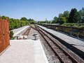
 Booking office and platforms, 2009 | |||||||||
| Type | Station | ||||||||
| Status |
Open Southern Terminus WHHR | ||||||||
| Location | |||||||||
| Latitude | 52:55:52N | ||||||||
| Longitude | 4:07:59W | ||||||||
| Grid reference | SH567392 | ||||||||
| Route Navigator | |||||||||
| |||||||||
| Stations | Locations | Bridges | Tunnels | Map | |||||||||
Porthmadog (WHHR) (sometimes known as Tremadog Road) is the southerly terminus of the Welsh Highland Heritage Railway and is located over the road from the Network Rail station. The WHR station was opened on 1st August 1980 and trains operate over the short line to Pen-y-mount.
The station is also the main administrative base for the Welsh Highland Railway Ltd.
In an attempt to distinguish the various Portmadoc/Porthmadog stations, both open and closed, this station has sometimes been referred to as Tremadog Road, a reference to its postal address. However, this has never been adopted by the WHR Ltd as it does not find favour with the working members.
-
 Porthmadog
 -
 Station sign
 -
 Station From Cambrian line
 -
 Porthmadog from car park
 -
 Porthmadog Signal box
 -
 Porthmadog from house
.jpg)

_Porthmadog_stn.jpg)
.jpg)
.jpg)